★ 5478 pts. ♥ 0 likes ⬇ 11 saves
![[Mapporn] How often world maps posted to MapPorn lack data for countries [1428x732] (#World #Posted #Countries #Data #Maps #Lack) - 174 KB Tags: countries, data, lack, maps, posted, world (Pict. in My r/MAPS favs)](https://t.im9.eu/mapporn-how-often-world-maps-posted-to-mapporn-lack-data-for-countries-1428x732.jpg) Pict. [Mapporn] Comparative Maps Of The 2011 Canadian Federal Election Of The Seat Distribution Under FPTP Voting And What It Would Ha (#Canadian #Maps #Distribution #Voting #Federal)Pict. 3300×3268 px
Pict. [Mapporn] Comparative Maps Of The 2011 Canadian Federal Election Of The Seat Distribution Under FPTP Voting And What It Would Ha (#Canadian #Maps #Distribution #Voting #Federal)Pict. 3300×3268 px★ 6572 pts. ♥ 0 likes ⬇ 8 saves
![[Mapporn] Comparative Maps Of The 2011 Canadian Federal Election Of The Seat Distribution Under FPTP Voting And What It Would Ha (#Canadian #Maps #Distribution #Voting #Federal) - 417 KB Tags: canadian, distribution, election, federal, maps, seat, voting (Pict. in My r/MAPS favs)](https://t.im9.eu/mapporn-comparative-maps-of-the-2011-canadian-federal-election-of-the-seat-distribution-under-fptp-voting-and-what-it-would-have-been-under-proportional-voting-3300x3268.jpg) Pict. [Mapporn] Blowfish: Use of 'Sick' Days by State [1063x765] (Source & More Maps in Comments) (#Source #State #Maps #Sick)Pict. 1063×765 px
Pict. [Mapporn] Blowfish: Use of 'Sick' Days by State [1063x765] (Source & More Maps in Comments) (#Source #State #Maps #Sick)Pict. 1063×765 px★ 5050 pts. ♥ 0 likes ⬇ 10 saves
![[Mapporn] Blowfish: Use of 'Sick' Days by State [1063x765] (Source & More Maps in Comments) (#Source #State #Maps #Sick) - 128 KB Tags: maps, sick, source, state (Pict. in My r/MAPS favs)](https://t.im9.eu/mapporn-blowfish-use-of-sick-days-by-state-1063x765-source-more-maps-in-comments.jpg) Pict. [Mapporn] We've all seen maps of landlocked countries...here's a map of landlocked first level administrative divisions [4972x25 (#Map #Countries #Divisions #Administrative #Landlocked)Pict. 4972×2517 px
Pict. [Mapporn] We've all seen maps of landlocked countries...here's a map of landlocked first level administrative divisions [4972x25 (#Map #Countries #Divisions #Administrative #Landlocked)Pict. 4972×2517 px★ 7125 pts. ♥ 0 likes ⬇ 10 saves
![[Mapporn] We've all seen maps of landlocked countries...here's a map of landlocked first level administrative divisions [4972x25 (#Map #Countries #Divisions #Administrative #Landlocked) - 261 KB Tags: administrative, countries, divisions, landlocked, level, map, maps (Pict. in My r/MAPS favs)](https://t.im9.eu/mapporn-we-ve-all-seen-maps-of-landlocked-countries-here-s-a-map-of-landlocked-first-level-administrative-divisions-4972x2517.jpg) Pict. [Mapporn] Hello! I make maps as a hobby. This one is of the Roman empire under Constantine the great [1380x1206] (#One #Great #Roman #Hobby #Constantine)Pict. 1206×1380 px
Pict. [Mapporn] Hello! I make maps as a hobby. This one is of the Roman empire under Constantine the great [1380x1206] (#One #Great #Roman #Hobby #Constantine)Pict. 1206×1380 px★ 5882 pts. ♥ 0 likes ⬇ 11 saves
![[Mapporn] Hello! I make maps as a hobby. This one is of the Roman empire under Constantine the great [1380x1206] (#One #Great #Roman #Hobby #Constantine) - 289 KB Tags: constantine, empire, great, hobby, maps, one, roman (Pict. in My r/MAPS favs)](https://t.im9.eu/mapporn-hello-i-make-maps-as-a-hobby-this-one-is-of-the-roman-empire-under-constantine-the-great-1380x1206.jpg) Pict. [Mapporn] Population Map 2015 3rd Edition + 4 Bonus Maps [7088x3008] (#3rd #Map #Population #Edition #Bonus #Maps)Pict. 7088×3008 px
Pict. [Mapporn] Population Map 2015 3rd Edition + 4 Bonus Maps [7088x3008] (#3rd #Map #Population #Edition #Bonus #Maps)Pict. 7088×3008 px★ 5513 pts. ♥ 0 likes ⬇ 3 saves
![[Mapporn] Population Map 2015 3rd Edition + 4 Bonus Maps [7088x3008] (#3rd #Map #Population #Edition #Bonus #Maps) - 3.7 MB Tags: 3rd, bonus, edition, map, maps, population (Pict. in My r/MAPS favs)](https://t.im9.eu/mapporn-population-map-2015-3rd-edition-4-bonus-maps-7088x3008.jpg) Pict. [Mapporn] Africa in Maps, made by Richard Edes Harrison, Sept. 1941 [5089x3214] (#Africa #Maps #Sept #Richard #Harrison)Pict. 5089×3214 px
Pict. [Mapporn] Africa in Maps, made by Richard Edes Harrison, Sept. 1941 [5089x3214] (#Africa #Maps #Sept #Richard #Harrison)Pict. 5089×3214 px★ 5422 pts. ♥ 0 likes ⬇ 6 saves
![[Mapporn] Africa in Maps, made by Richard Edes Harrison, Sept. 1941 [5089x3214] (#Africa #Maps #Sept #Richard #Harrison) - 4.3 MB Tags: africa, harrison, maps, richard, sept (Pict. in My r/MAPS favs)](https://t.im9.eu/mapporn-africa-in-maps-made-by-richard-edes-harrison-sept-1941-5089x3214.jpg) Pict. [Mapporn] History of World War II, a 3-sheet map published in the San Francisco Examiner in 1945. (Individual Hi-Res Maps in Com (#Res #World #Map #Com #Maps #Sheet #Published #Individual)Pict. 5891×2663 px
Pict. [Mapporn] History of World War II, a 3-sheet map published in the San Francisco Examiner in 1945. (Individual Hi-Res Maps in Com (#Res #World #Map #Com #Maps #Sheet #Published #Individual)Pict. 5891×2663 px★ 7878 pts. ♥ 0 likes ⬇ 10 saves
![[Mapporn] History of World War II, a 3-sheet map published in the San Francisco Examiner in 1945. (Individual Hi-Res Maps in Com (#Res #World #Map #Com #Maps #Sheet #Published #Individual) - 4.4 MB Tags: com, francisco, history, individual, map, maps, published, res, san, sheet, war, world (Pict. in My r/MAPS favs)](https://t.im9.eu/mapporn-history-of-world-war-ii-a-3-sheet-map-published-in-the-san-francisco-examiner-in-1945-individual-hi-res-maps-in-comments-5891x2663.jpg) GIF [Dataisbeautiful] Animated GIF of '188 drought maps reveal just how thirsty California has become' (#Gif #Animated #Reveal #Thirsty #Drought)GIF 130×130 px
GIF [Dataisbeautiful] Animated GIF of '188 drought maps reveal just how thirsty California has become' (#Gif #Animated #Reveal #Thirsty #Drought)GIF 130×130 px★ 4063 pts. ♥ 0 likes ⬇ 6 saves
![[Dataisbeautiful] Animated GIF of '188 drought maps reveal just how thirsty California has become' (#Gif #Animated #Reveal #Thirsty #Drought) - 851 KB Tags: animated, california, drought, gif, maps, reveal, thirsty (GIF in My r/DATAISBEAUTIFUL favs)](https://t.im9.eu/dataisbeautiful-animated-gif-of-188-drought-maps-reveal-just-how-thirsty-california-has-become.jpg) Pict. [Pics] My mate does incredible portraits on maps 7 (#Incredible #Maps #Portraits #Mate)Pict. 700×913 px
Pict. [Pics] My mate does incredible portraits on maps 7 (#Incredible #Maps #Portraits #Mate)Pict. 700×913 px★ 9245 pts. ♥ 0 likes ⬇ 7 saves
![[Pics] My mate does incredible portraits on maps 7 (#Incredible #Maps #Portraits #Mate) - 191 KB Tags: incredible, maps, mate, portraits (Pict. in My r/PICS favs)](https://t.im9.eu/pics-my-mate-does-incredible-portraits-on-maps-7.jpg) Pict. [Pics] My mate does incredible portraits on maps 5 (#Incredible #Maps #Portraits #Mate)Pict. 700×967 px
Pict. [Pics] My mate does incredible portraits on maps 5 (#Incredible #Maps #Portraits #Mate)Pict. 700×967 px★ 9045 pts. ♥ 0 likes ⬇ 4 saves
![[Pics] My mate does incredible portraits on maps 5 (#Incredible #Maps #Portraits #Mate) - 232 KB Tags: incredible, maps, mate, portraits (Pict. in My r/PICS favs)](https://t.im9.eu/pics-my-mate-does-incredible-portraits-on-maps-5.jpg) Pict. [Pics] My mate does incredible portraits on maps 3 (#Incredible #Maps #Portraits #Mate)Pict. 700×762 px
Pict. [Pics] My mate does incredible portraits on maps 3 (#Incredible #Maps #Portraits #Mate)Pict. 700×762 px★ 8898 pts. ♥ 0 likes ⬇ 2 saves
![[Pics] My mate does incredible portraits on maps 3 (#Incredible #Maps #Portraits #Mate) - 194 KB Tags: incredible, maps, mate, portraits (Pict. in My r/PICS favs)](https://t.im9.eu/pics-my-mate-does-incredible-portraits-on-maps-3.jpg) Pict. [Mapporn] Putting some countries where Greenland is in a Mercator Map [maps] [696x2484] (#Map #Countries #Greenland #Mercator #696x2484)Pict. 696×2484 px
Pict. [Mapporn] Putting some countries where Greenland is in a Mercator Map [maps] [696x2484] (#Map #Countries #Greenland #Mercator #696x2484)Pict. 696×2484 px★ 6493 pts. ♥ 0 likes ⬇ 5 saves
![[Mapporn] Putting some countries where Greenland is in a Mercator Map [maps] [696x2484] (#Map #Countries #Greenland #Mercator #696x2484) - 357 KB Tags: 696x2484, countries, greenland, map, maps, mercator, putting (Pict. in My r/MAPS favs)](https://t.im9.eu/mapporn-putting-some-countries-where-greenland-is-in-a-mercator-map-maps-696x2484.jpg) Pict. [Mildlyinteresting] Google Maps knows what floor I'm on (#Google #Floor #Maps)Pict. 640×960 px
Pict. [Mildlyinteresting] Google Maps knows what floor I'm on (#Google #Floor #Maps)Pict. 640×960 px★ -12094 pts. ♥ 0 likes ⬇ 13 saves
![[Mildlyinteresting] Google Maps knows what floor I'm on (#Google #Floor #Maps) - 60 KB Tags: floor, google, maps (Pict. in My r/MILDLYINTERESTING favs)](https://t.im9.eu/mildlyinteresting-google-maps-knows-what-floor-i-m-on.jpg) Pict. [Mapporn] James Bond World Travel Maps [700 x 4905] (#World #James #Maps #Travel #Bond)Pict. 700×4905 px
Pict. [Mapporn] James Bond World Travel Maps [700 x 4905] (#World #James #Maps #Travel #Bond)Pict. 700×4905 px★ 5147 pts. ♥ 0 likes ⬇ 6 saves
![[Mapporn] James Bond World Travel Maps [700 x 4905] (#World #James #Maps #Travel #Bond) - 520 KB Tags: bond, james, maps, travel, world (Pict. in My r/MAPS favs)](https://t.im9.eu/mapporn-james-bond-world-travel-maps-700-x-4905.jpg) Pict. [Mapporn] Stylized empire maps from the game Civilization V (full album in comments)[347x403] (#Album #Game #Empire #Civilization #Stylized)Pict. 347×403 px
Pict. [Mapporn] Stylized empire maps from the game Civilization V (full album in comments)[347x403] (#Album #Game #Empire #Civilization #Stylized)Pict. 347×403 px★ 6434 pts. ♥ 0 likes ⬇ 7 saves
![[Mapporn] Stylized empire maps from the game Civilization V (full album in comments)[347x403] (#Album #Game #Empire #Civilization #Stylized) - 47 KB Tags: album, civilization, empire, full, game, maps, stylized (Pict. in My r/MAPS favs)](https://t.im9.eu/mapporn-stylized-empire-maps-from-the-game-civilization-v-full-album-in-comments-347x403.jpg) Pict. [Mapporn] You can use the Google Maps' traffic feature to see where the winter storm has been. [640 x 1146] (#Winter #Google #Storm #Maps #Traffic #Feature)Pict. 640×1136 px
Pict. [Mapporn] You can use the Google Maps' traffic feature to see where the winter storm has been. [640 x 1146] (#Winter #Google #Storm #Maps #Traffic #Feature)Pict. 640×1136 px★ 5629 pts. ♥ 0 likes ⬇ 2 saves
![[Mapporn] You can use the Google Maps' traffic feature to see where the winter storm has been. [640 x 1146] (#Winter #Google #Storm #Maps #Traffic #Feature) - 226 KB Tags: feature, google, maps, storm, traffic, winter (Pict. in My r/MAPS favs)](https://t.im9.eu/mapporn-you-can-use-the-google-maps-traffic-feature-to-see-where-the-winter-storm-has-been-640-x-1146.jpg) Pict. [Mapporn] Three Approaches to the U.S.: WW-II era tilted perspective maps from viewpoints above Berlin, Tokyo, and Caracas. [161 (#Maps #Tokyo #Berlin #Tilted #Caracas #Viewpoints)Pict. 1617×2074 px
Pict. [Mapporn] Three Approaches to the U.S.: WW-II era tilted perspective maps from viewpoints above Berlin, Tokyo, and Caracas. [161 (#Maps #Tokyo #Berlin #Tilted #Caracas #Viewpoints)Pict. 1617×2074 px★ 7389 pts. ♥ 0 likes ⬇ 6 saves
![[Mapporn] Three Approaches to the U.S.: WW-II era tilted perspective maps from viewpoints above Berlin, Tokyo, and Caracas. [161 (#Maps #Tokyo #Berlin #Tilted #Caracas #Viewpoints) - 604 KB Tags: approaches, berlin, caracas, era, maps, perspective, tilted, tokyo, viewpoints (Pict. in My r/MAPS favs)](https://t.im9.eu/mapporn-three-approaches-to-the-u-s-ww-ii-era-tilted-perspective-maps-from-viewpoints-above-berlin-tokyo-and-caracas-1617-2074.jpg) Pict. [Mildlyinteresting] Spotted and underwater submarine on google maps 2 (#Google #Maps #Spotted #Underwater #Submarine)Pict. 1300×873 px
Pict. [Mildlyinteresting] Spotted and underwater submarine on google maps 2 (#Google #Maps #Spotted #Underwater #Submarine)Pict. 1300×873 px★ -11042 pts. ♥ 0 likes ⬇ 9 saves
![[Mildlyinteresting] Spotted and underwater submarine on google maps 2 (#Google #Maps #Spotted #Underwater #Submarine) - 163 KB Tags: google, maps, spotted, submarine, underwater (Pict. in My r/MILDLYINTERESTING favs)](https://t.im9.eu/mildlyinteresting-spotted-and-underwater-submarine-on-google-maps-2.jpg) Pict. [Mildlyinteresting] Spotted and underwater submarine on google maps 1 (#Google #Maps #Spotted #Underwater #Submarine)Pict. 1301×874 px
Pict. [Mildlyinteresting] Spotted and underwater submarine on google maps 1 (#Google #Maps #Spotted #Underwater #Submarine)Pict. 1301×874 px★ -11080 pts. ♥ 0 likes ⬇ 6 saves
![[Mildlyinteresting] Spotted and underwater submarine on google maps 1 (#Google #Maps #Spotted #Underwater #Submarine) - 56 KB Tags: google, maps, spotted, submarine, underwater (Pict. in My r/MILDLYINTERESTING favs)](https://t.im9.eu/mildlyinteresting-spotted-and-underwater-submarine-on-google-maps-1.jpg) Pict. [Mapporn] Hand crafted topographical map of Banks Peninsula, New Zealand (Contour lines are at 100m intervals. More maps in comm (#New #Map #Are #Hand #Lines #Comm #Contour #Crafted #Intervals)Pict. 960×720 px
Pict. [Mapporn] Hand crafted topographical map of Banks Peninsula, New Zealand (Contour lines are at 100m intervals. More maps in comm (#New #Map #Are #Hand #Lines #Comm #Contour #Crafted #Intervals)Pict. 960×720 px★ 8998 pts. ♥ 0 likes ⬇ 20 saves
![[Mapporn] Hand crafted topographical map of Banks Peninsula, New Zealand (Contour lines are at 100m intervals. More maps in comm (#New #Map #Are #Hand #Lines #Comm #Contour #Crafted #Intervals) - 137 KB Tags: are, banks, comm, contour, crafted, hand, intervals, lines, map, maps, new, peninsula, topographical, zealand (Pict. in My r/MAPS favs)](https://t.im9.eu/mapporn-hand-crafted-topographical-map-of-banks-peninsula-new-zealand-contour-lines-are-at-100m-intervals-more-maps-in-comments-oc-960x720.jpg) Pict. [Mildlyinteresting] Google Maps satellite imagery captured troop formations in Kim Il-sung Stadium, North Korea (#North #Google #Korea #Maps #Formations #Sung #Troop #Imagery)Pict. 1300×749 px
Pict. [Mildlyinteresting] Google Maps satellite imagery captured troop formations in Kim Il-sung Stadium, North Korea (#North #Google #Korea #Maps #Formations #Sung #Troop #Imagery)Pict. 1300×749 px★ -8669 pts. ♥ 0 likes ⬇ 17 saves
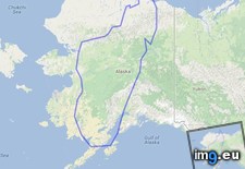
![[Mildlyinteresting] Google Maps satellite imagery captured troop formations in Kim Il-sung Stadium, North Korea (#North #Google #Korea #Maps #Formations #Sung #Troop #Imagery) - 238 KB Tags: captured, formations, google, imagery, kim, korea, maps, north, satellite, stadium, sung, troop (Pict. in My r/MILDLYINTERESTING favs)](https://t.im9.eu/mildlyinteresting-google-maps-satellite-imagery-captured-troop-formations-in-kim-il-sung-stadium-north-korea.jpg) Pict. mapporn-the-island-of-madagascar-compared-to-alaska-543-524 (#White #World #Map #Wide #Europe #Maps #Asia #Compared #Geography #Stats #Madagascar)Pict. 543×524 px
Pict. mapporn-the-island-of-madagascar-compared-to-alaska-543-524 (#White #World #Map #Wide #Europe #Maps #Asia #Compared #Geography #Stats #Madagascar)Pict. 543×524 px★ 9130 pts. ♥ 0 likes ⬇ 6 saves
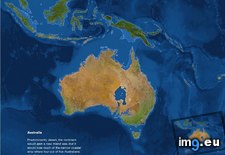
 Pict. mapporn-what-australia-and-surrounding-territories-would-look-like-if-all-the-ice-on-earth-were-to-melt-australia-1-024px-766px (#White #Map #Best #Wide #Europe #Ice #Asia #Territories #Melt #Stats #Surrounding #Statistics)Pict. 1024×766 px
★ 9857 pts. ♥ 0 likes ⬇ 8 saves
